Do you use Google Earth and it's Time Slider?

robby4570

Elite Member
Joined
Feb 6, 2011
Messages
4,815
Location
Ama LA
To find your coordinates and mark the points you want to hit?

I did this for a local park where there are events held regularly....

I found using the time slider where the tents get set up at and where the parking rows are. Then I drop a marker at each end of the rows and draw a line between using the path tool, this will be the center line of my path. All of these markers are saved into a unique folder in GE myplaces so I can look back at them later. I save a .kmz file to my computer and then go to http://www.gpsvisualizer.com/ to convert the .kmz to a .gpx file so I can open it in GSAK - Geocaching Swiss Army Knife - (just http://gsak.net/ ) to edit the waypoints. When done editing, I re-save the file and email it to my phone. Once in my phone I synch the .gpx file with Geobeagle and I have a list of targets that I can then navigate to using the GPS on my phone - I have an Android phone.

I know it seems like a lot of work but to get markers from Google Earth as GPS points I can use my phone to navigate to, it's really not that bad and pretty well worth the effort. I suppose you could skip the GSAK step and just open the .gpz from the conversion with Geobeagle once the .gpx is on your phone or synch the .gpx with your GPSr...
 
What? You guys find this not helpful? 45 views and no comments? I know a lot of you do your research with GE...
 
I use the overlay feature
found plat maps for my area and over lay the and tr to figure out where building where
put the GPS #s in my buddies GPS and start walking
sometimes it works sometimes I dont find anything
Its hard when you zoom in the square for the building is a hundred yards across
 
Man, I wish I understood what you are talking about!!!!! I have looked for maps for my area (Nashville TN and Middle TN) and have found very little help. My hunting is more for coins. But, I would not turn down the opportunity to find some relics.

If i could find some useful maps, I might try to overlay like you suggest. I'll keep trying!

Thanks for the info
Mike
 
To find your coordinates and mark the points you want to hit?

I did this for a local park where there are events held regularly....

I found using the time slider where the tents get set up at and where the parking rows are. Then I drop a marker at each end of the rows and draw a line between using the path tool, this will be the center line of my path. All of these markers are saved into a unique folder in GE myplaces so I can look back at them later. I save a .kmz file to my computer and then go to http://www.gpsvisualizer.com/ to convert the .kmz to a .gpx file so I can open it in GSAK - Geocaching Swiss Army Knife - (just http://gsak.net/ ) to edit the waypoints. When done editing, I re-save the file and email it to my phone. Once in my phone I synch the .gpx file with Geobeagle and I have a list of targets that I can then navigate to using the GPS on my phone - I have an Android phone.

I know it seems like a lot of work but to get markers from Google Earth as GPS points I can use my phone to navigate to, it's really not that bad and pretty well worth the effort. I suppose you could skip the GSAK step and just open the .gpz from the conversion with Geobeagle once the .gpx is on your phone or synch the .gpx with your GPSr...

Another alternative (supplementary idea) If you use iPhone or Android...don't deny yourself the Maprika smartphone app too.. Especially if you have digital versions of old maps available in high resolution. You can drive right to the old locations by just watching the map as you drive. Old stuff just scrolls by. It's like time travel.

http://www.detecting.us/2012/10/30/using-maprika-for-metal-detecting/

Thanks for sharing this....I just spent 90 minutes or so getting some maps set up, can't wait to get in the field and see how this does.....This looks like a killer tool!
 
Man, I wish I understood what you are talking about!!!!! I have looked for maps for my area (Nashville TN and Middle TN) and have found very little help. My hunting is more for coins. But, I would not turn down the opportunity to find some relics.

If i could find some useful maps, I might try to overlay like you suggest. I'll keep trying!

Thanks for the info
Mike

try your local college university thats where I found my maps
 
Academically I might be knowledgeable, technically I'm a bit of a"Dumbo!" I am amazed at the ability of many members and their technical "know how!" It sure helps people like me and sheds light where once there was only darkness!
 
On Google Earth... Some images are made in winter, others in autumn. This can really help with visibility through tree cover. Here in KY, the 1997 images are not quite as sharp, but the trees are barren, so when I have a spot with leaves - I switch over and look through them.
 
See? I KNEW this was a good topic...

to get some idea and info sharing going!! Thanks y'all!
:friends: :gottaluv: :friends:
 
Man if I ever get a desktop computer this is gonna be great! The only internet I have is on my phone, and its not capable of much more than internet browsing. Definitely worth bookmarking for later use! thanks!
 
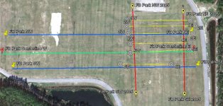
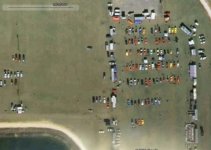
Well, I did it, I tested my process and research. And it worked out very well. I have a big sports park near me and I decided to pull it up in GE and slide the time slider to look at historical imagery. And lo and behold, in 2007 and 2005 there's images of lots of activity in a certain area of the park.

Here's the area in 2012:

FBP 2007&2005 Grids.jpg


Here it is in 2007:

FBP 2007 Grid.jpg


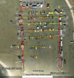
Here it is in 2005:

FBP 2005.jpg

FBP 2005 Grid.jpg


Now I dropped markers onto the map at the ends of rows of tents and parking, then used the path tool to draw lines between the markers on the rows so I will have a path to MD along. These markers and paths will be on every year image I pull up. I then exported the folder that the markers were in to a KML file on my computer. I took the file on-line to http://www.gpsvisualizer.com and converted that kml file to a gpx file and opened it in GSAK. I edited the waypoints (markers) and saved them. Then I emailed that file to my phone and opened it in Geobeagle. Now I can navigate to a marker in real life on the field and MD to another point using the GPS on my phone.

After just a couple hours going along a few of these line, I got this:

16577_10152391085375635_2083292884_n.jpg

So in closing, I didn't get a lot but I got a lot more in two hours than I have gotten in this field on twice as long previous hunts. I feel that I gave myself the highest probability of targets by hunting the most used spots... And I only hit about 15% of it because I was just out for fun today, and this was my first hunt of 2013!
 
I do use Google Earth but the time line option only goes back 15 years I think. I use http://www.historicaerials.com more than any others. aerial maps of most places back to the 1930's

Just to 1994, you won't find turn of the last century satellite coverage but you can see foundations and old roads and trails. My process will work great for identifying them and marking coordinates.
 
Back
Top Bottom