
40acre1870
Forum Supporter
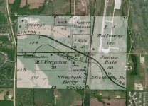
I was looking at some plat maps from 1879 last night and then. Bingo!
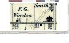
I found farm field that is about 4 miles from my house that had a school there. It is on the 1879, 1897 & 1919 plat maps. I do not know the history of the school, but I know it was there.
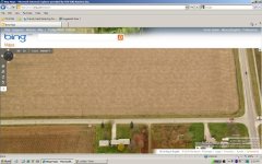
To top it off... across the road there were five houses all within a half mile that is now all farm land.
I know who farms it and I know them well. Their uncle who passed away last year at the age of 89 was my neighbor and they took over his farm. These guys could be a wealth of imformation as they own and farm more land in my county than anyone else. They farm the land to the west, the east and the north of me, so I am always talking to them, but I have never talked about metal detecting.
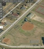
I would like to have arial photos in hand when I speak to them about certain fields in the area. I see people on here who can post a map on the forum where thay have circled locations on the map, but I am unfortunately not up to speed.
Sorry if this sounds confusing as I am confused myself.
Thanks
Mike
I found farm field that is about 4 miles from my house that had a school there. It is on the 1879, 1897 & 1919 plat maps. I do not know the history of the school, but I know it was there.
To top it off... across the road there were five houses all within a half mile that is now all farm land.
I know who farms it and I know them well. Their uncle who passed away last year at the age of 89 was my neighbor and they took over his farm. These guys could be a wealth of imformation as they own and farm more land in my county than anyone else. They farm the land to the west, the east and the north of me, so I am always talking to them, but I have never talked about metal detecting.
I would like to have arial photos in hand when I speak to them about certain fields in the area. I see people on here who can post a map on the forum where thay have circled locations on the map, but I am unfortunately not up to speed.
Sorry if this sounds confusing as I am confused myself.
Thanks
Mike
 ... j/k heath
")