You are using an out of date browser. It may not display this or other websites correctly.
You should upgrade or use an alternative browser.
You should upgrade or use an alternative browser.
Looking for a hunting buddy in Louisiana
- Thread starter robby4570
- Start date
I'm in ponchatoula, but probably wont have time to get together until after new years.
Me too on that New Years part... We keep our boat at a Marina in Madisonville, the Marina Manager wants to get into detecting so we may get together up there after New Years too. I'm not familiar with that area being that we live an hour away. If you have or know of any spots up there, I have a few down here I'm willing to share.
Me too on that New Years part... We keep our boat at a Marina in Madisonville, the Marina Manager wants to get into detecting so we may get together up there after New Years too. I'm not familiar with that area being that we live an hour away. If you have or know of any spots up there, I have a few down here I'm willing to share.
Sounds good to me. Let me know when yall get together and if I'm available I'll join yall. I know a lot of parks, ballfields, sports complexes, etc. that we can hit. Doing some research on some older sites and possible CW camp sites in my area but that's still a work in progress.
Sounds good to me. Let me know when yall get together and if I'm available I'll join yall. I know a lot of parks, ballfields, sports complexes, etc. that we can hit. Doing some research on some older sites and possible CW camp sites in my area but that's still a work in progress.
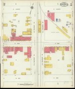
Sure will, do you use an app and computer program called MAPRIKA (GPS On Ski Maps in the app store) for mapping? I've been using it for many years and it's taken me to some great sites. I found a good set of Sanborn maps of Ponchatoula that I could import into the program and upload... this is a Sanborn series in the demo video
Sure will, do you use an app and computer program called MAPRIKA (GPS On Ski Maps in the app store) for mapping? I've been using it for many years and it's taken me to some great sites. I found a good set of Sanborn maps of Ponchatoula that I could import into the program and upload... this is a Sanborn series in the demo video
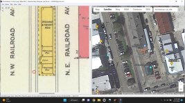
As a matter of fact, the maps I found are 1925 Sanborns. I did one and looked at it for a bit. Have you ever detected the (looks like at least) grass strip on NW Railroad between Pine and Hickory? That's right in front of the old Railroad Depot it looks like with 2 waiting rooms... Might have been some old coins dropped there while folks were waiting for the trains...
As a matter of fact, the maps I found are 1925 Sanborns. I did one and looked at it for a bit. Have you ever detected the (looks like at least) grass strip on NW Railroad between Pine and Hickory? That's right in front of the old Railroad Depot it looks like with 2 waiting rooms... Might have been some old coins dropped there while folks were waiting for the trains...
Very cool! I am aware of Maprika but I have not used it personally. I will sometimes bring an old map into ArcGIS but its a little more involved process to georeference them correctly. I'll download maprika and play around with it a bit.
Ah yes, the old sanborn maps. I actually have a set from 1908 and 1923 for ponchatoula as well, but the 1925 ones you're working with are the most complete view of the town. The blocks marked "public squares" on the west side of the tracks are both still parks today. The one north of Hwy 22 (Pine st.) is where they hold the strawberry festival every year. I've hit those before and found some good stuff but I know there's more there. The "public squares" on the east side of the tracks are currently a school and the middle/high school's baseball field. I'd like to do the old school block, but it's still in use as the town's middle school and the whole thing is fenced off. I haven't gotten around to asking permission there yet but I imagine it's loaded with goodies.
I have never done that grass strip next to the depot. I bet there's some good stuff there, but I imagine it would be tough digging given it's proximity to the tracks and all the gravel and iron from the old railbeds. But yeah, we should check it out.
I also have topo maps from the 1930s that I've used to find old homesites that are no longer there.
Ponchatoula has a good bit of CW history as well. The Battle of Ponchatoula is pretty well documented and I know some of those sites have been hit hard in the past. But as they say, a site is never hunted out. Something I'm working on now is using a map from the 1890s and archived letters and soldier's reports to find some (hopefully) previously undetected CW bivouac sites between Ponchatoula and Baton Rouge.
The whole northshore area in general has a lot of history going back to the 1700s. I talked to a guy a few years ago that found a Spanish 8 Reale only a few inches down in a sidewalk strip in old Covington.
Similar threads
- Replies
- 2
- Views
- 68


