SofiyaLitski
New Member
- Joined
- Apr 12, 2022
- Messages
- 6
I am trying to answer a couple of questions about old black and white aerial photos.
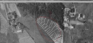
1) What is this field of white lines I see on my first attachment? On the left house, there is even a field of white dots. Note: that this might be swamp/water related as there is water there now.
2) This photo is from the 1930's. Shouldn't there be a visible path to an outhouse? Can the outhouse or garbage dump be located on the maps?
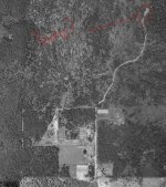
3) Is it possible to see old dumps on the maps? Could this second image show a dump? It's relatively close to a graveyard (not pictured) but not close to a body of water. A well defined road going to nowhere seems suspicious to me.
Thank you for reading.
1) What is this field of white lines I see on my first attachment? On the left house, there is even a field of white dots. Note: that this might be swamp/water related as there is water there now.
2) This photo is from the 1930's. Shouldn't there be a visible path to an outhouse? Can the outhouse or garbage dump be located on the maps?
3) Is it possible to see old dumps on the maps? Could this second image show a dump? It's relatively close to a graveyard (not pictured) but not close to a body of water. A well defined road going to nowhere seems suspicious to me.
Thank you for reading.