Map Symbol Help

Bill_Ace_350

Elite Member
Joined
Apr 26, 2011
Messages
1,326
Location
Upstate New York
The symbol in image 1 occuoies the confirmed location of a fair ground found on an 1860's map. The same symbol appears in image 2, same map, different location. Am not familiar with this symbol. Any ideas? Thanks.
 

Attachments

  • image 1.jpg
    image 1.jpg
    5.1 KB · Views: 145
  • image 2.jpg
    image 2.jpg
    5.7 KB · Views: 145
I agree. It was definitely a horse track. This is a great location to hunt. I've hunted one with my dad and uncle and we found loads of coins. Not counting how many people the owner had said had already been there. Just one question. Where did you find the map? Online? What site?
 
Thanks for the responses. I thought it could be a track also, but still not sure about the second image. Drive past that location twice a day, and it is just farm field now, about a mile outside of the village. None of the oldtimers remember any stories about any race tracks. I know the farmer who owns it. Will ask him for permission to take a look around.

I use maps mainly from the following sites:

http://docs.unh.edu/nhtopos/nhtopos.htm

http://nationalmap.gov/historical/
 
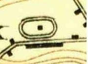
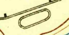
In my area of the world, that symbol almost always means a race track that was usually found in conjunction with a fair grounds.

However, there are some places that have a high density of tracks because the region is known for training horses. I've found a few places that have 4 or 5 tracks in a 10 mile radius. Anyhow, if they are fairly close to one another, you might want to dig a little deeper and see if the area is known for training horses.

Top
 
Back
Top Bottom