To help locate ancient settlements in Europe, I have found a technique I have used over the last three years that has worked very well for me. I now share this with you all.
The first part is understand where ancient people lived. They did not live in cities and towns. Very few even lived in villages. About 94% of all people in Europe lived directly on agriculteral fields, near sources of fresh water. Irrigation ditches were dug in the Neolithic period, and expanded in the Bronze and certainly by the Iron ages. The Romans simply used existing irrigation channels, and even built their dwellings over pre-existing areas of habitation. This is mostly due to the fact that Romans were an incorporated people. Iron age Celts assimilated into Roman life – and used the advances of Roman economy and technology to build modern homes on or near existing Iron age sites, who in-turn built their own dwellings on existing bronze age sites etc.
So the first thing is to look for areas that would appeal to someone farming the land, and near water. Irrigation channels are a major clue to look for. Second you do not want to waste your time digging modern trash, so you want to search for areas well away from modern villages and towns, and miles away from any city. The more isolated the better.
You then use Google Earth to scan rivers and streams, and then look for irrigation canals leading out across cultivated farmland. You are looking for small fields which look like strips of varying earth tones, not forests These show the boundaries of small fields which were either held by individual families or simply separated a variety of crops. Forests may indeed yield ancient sites, that have simply grown back to forest, but they are not as easy to spot, and I will not focuis on those areas in this discussion.
The key to finding good sites lies in the fact that most European farm soils have good 'soil memory'; that is, they retain traces of chemical and physical transformations. Humans from the Neolithic and Copper Age through to the early middle age communities used local earth and clay to plaster their floors and walls, make pottery and figurines, grow crops and create houses. They tilled, mixed, burned, trampled, fertilized and shaped their landscapes. I find it fascinating to use satellite imaging to note the changing nature of the soil (such effects on plants due to pH changes, soil density, and moisture) brought about through tasks such as cooking, farming and disposing of waste, and soil compaction through human settlement and animal husbandry.
Look carefully for fields that are near streams, or irrigation ditches, and locate fields that show shadows and highlighted areas in the fields. The shadows can mean filled-in trenches that used to surrounded ancient huts, large Roman villas, or even small settlements. The highlights show compacted earth, where people and/or animals walked. They can also indicate where ancient people lived – in organic structures that have since decayed away.
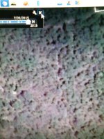
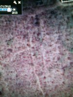
Take a look at these two photos of the exact same fields. The image on the left is the current view as seen today, if you use Google Earth or Google Maps. The area interested me because it was near a brook, far from any villages, and had some faint shadows. Next, I selected Google Earth’s "historical imagery" option under the View menu. From there I flipped through previous satellite images taken over the last several years. Some are not usable, due to clouds or nightfall. But a few were good shots, taken at various times during the year. I found one, taken during a dry spell when the crops had not been planted. It showed a distinct circular shadow on the ground. I confirmed this with other dates and found that it existed in imagery taken in 2005, 2008 and again in 2012. This shows the patterns are not a one-off effect of plowing one year.
The lighter area is denser ground, and the pattern is 100 meters across - which makes it a very large and interesting feature. I call it a Celtic donut.

The next step was to get permisison to enter the property. Once this is achieved, I drove out to this feature, and using a hand-held GPS walked to the center of the "donut". I discovered that it was actually raised above the surrounding field by about 1/2 meter. When I looked down at the ground it was littered with pottery shards. But it was Neolithic, well before the Bronze or Iron age.
I searched with the detectors, but no metal was found. Had I dug and sifted, I probably would have found stone age tools, such as flint arrowheads and blades. The site was probably a Neolithic burial or ceremonial mound. It could contain burial urns with cremated remains.
I have used this technique a lot over the last two years, and have found dozens of Roman sites this way. The image below show an irrigation canal with lots of ancient activity along the edges. But the image also shows clear square ditches (dark color) and stone foundation walls (white) – all in red below.

Here's one the shows no signs in the normal Google maps online, but when looked at in Google Earth's with the technique I describe above, I was able to suddently see areas that were worth investigating further!

By using this technique, and learning what are simply natural features, and what are actually man-made, you can zero in on areas that are worth searching. The area above yielded lots of Roman coins and other small metal artifacts from the 3rd and 4th century!
I leave you with one more... an amazing area that shows no sign on any image in Google Maps, but oin one year (2012) in Google Earth all this popped out! People drive by these fields and have no idea what is lying below the surface. Amazing fields, full of settlements from the Neolithic through the Romans.

The first part is understand where ancient people lived. They did not live in cities and towns. Very few even lived in villages. About 94% of all people in Europe lived directly on agriculteral fields, near sources of fresh water. Irrigation ditches were dug in the Neolithic period, and expanded in the Bronze and certainly by the Iron ages. The Romans simply used existing irrigation channels, and even built their dwellings over pre-existing areas of habitation. This is mostly due to the fact that Romans were an incorporated people. Iron age Celts assimilated into Roman life – and used the advances of Roman economy and technology to build modern homes on or near existing Iron age sites, who in-turn built their own dwellings on existing bronze age sites etc.
So the first thing is to look for areas that would appeal to someone farming the land, and near water. Irrigation channels are a major clue to look for. Second you do not want to waste your time digging modern trash, so you want to search for areas well away from modern villages and towns, and miles away from any city. The more isolated the better.
You then use Google Earth to scan rivers and streams, and then look for irrigation canals leading out across cultivated farmland. You are looking for small fields which look like strips of varying earth tones, not forests These show the boundaries of small fields which were either held by individual families or simply separated a variety of crops. Forests may indeed yield ancient sites, that have simply grown back to forest, but they are not as easy to spot, and I will not focuis on those areas in this discussion.
The key to finding good sites lies in the fact that most European farm soils have good 'soil memory'; that is, they retain traces of chemical and physical transformations. Humans from the Neolithic and Copper Age through to the early middle age communities used local earth and clay to plaster their floors and walls, make pottery and figurines, grow crops and create houses. They tilled, mixed, burned, trampled, fertilized and shaped their landscapes. I find it fascinating to use satellite imaging to note the changing nature of the soil (such effects on plants due to pH changes, soil density, and moisture) brought about through tasks such as cooking, farming and disposing of waste, and soil compaction through human settlement and animal husbandry.
Look carefully for fields that are near streams, or irrigation ditches, and locate fields that show shadows and highlighted areas in the fields. The shadows can mean filled-in trenches that used to surrounded ancient huts, large Roman villas, or even small settlements. The highlights show compacted earth, where people and/or animals walked. They can also indicate where ancient people lived – in organic structures that have since decayed away.
Take a look at these two photos of the exact same fields. The image on the left is the current view as seen today, if you use Google Earth or Google Maps. The area interested me because it was near a brook, far from any villages, and had some faint shadows. Next, I selected Google Earth’s "historical imagery" option under the View menu. From there I flipped through previous satellite images taken over the last several years. Some are not usable, due to clouds or nightfall. But a few were good shots, taken at various times during the year. I found one, taken during a dry spell when the crops had not been planted. It showed a distinct circular shadow on the ground. I confirmed this with other dates and found that it existed in imagery taken in 2005, 2008 and again in 2012. This shows the patterns are not a one-off effect of plowing one year.
The lighter area is denser ground, and the pattern is 100 meters across - which makes it a very large and interesting feature. I call it a Celtic donut.
The next step was to get permisison to enter the property. Once this is achieved, I drove out to this feature, and using a hand-held GPS walked to the center of the "donut". I discovered that it was actually raised above the surrounding field by about 1/2 meter. When I looked down at the ground it was littered with pottery shards. But it was Neolithic, well before the Bronze or Iron age.
I searched with the detectors, but no metal was found. Had I dug and sifted, I probably would have found stone age tools, such as flint arrowheads and blades. The site was probably a Neolithic burial or ceremonial mound. It could contain burial urns with cremated remains.
I have used this technique a lot over the last two years, and have found dozens of Roman sites this way. The image below show an irrigation canal with lots of ancient activity along the edges. But the image also shows clear square ditches (dark color) and stone foundation walls (white) – all in red below.
Here's one the shows no signs in the normal Google maps online, but when looked at in Google Earth's with the technique I describe above, I was able to suddently see areas that were worth investigating further!
By using this technique, and learning what are simply natural features, and what are actually man-made, you can zero in on areas that are worth searching. The area above yielded lots of Roman coins and other small metal artifacts from the 3rd and 4th century!
I leave you with one more... an amazing area that shows no sign on any image in Google Maps, but oin one year (2012) in Google Earth all this popped out! People drive by these fields and have no idea what is lying below the surface. Amazing fields, full of settlements from the Neolithic through the Romans.