LovestheShiny!
Forum Supporter
Ahh.... something a bit tedious but something that I've found important for metal detecting curb / parking strips and private homes... recordkeeping!
The Sanborn Map Company began drawing maps of towns and cities in America going back to 1884, and these detailed and very accurate drawings were used for fire insurance information. They are like an early google view of the town, showing hotels, ballfields, parks, homes, businesses, racetracks, rodeo and fairgrounds, and other features of interest to detectorists. I am not going to get into that good aspect of the Sanborn Maps on this thread, just that they are great for dating a particular neighborhood and individual homes, AND they allow for great recordkeeping as to WHERE you have previously detected and WHAT PRIVATE HOMES you have ALREADY detected.
These maps exist for pretty much every town and city in the United States. Many of these maps are available for printing or browsing at your local library, local museum or historical society, and some states have the maps available for browsing, downloading or printing from the internet.
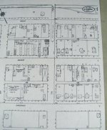
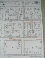
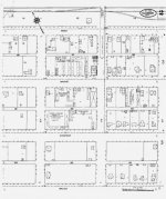
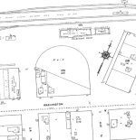
The pictures below show a page of the Sanborn Maps for GLASGOW MONTANA in October of 1910, one page out of four pages that are available for that year. Each page can easily be printed on an 11" by 17" or 8 1/2" by 11" format. The maps tell me where homes were located, and give good prospects on which ones to detect. Most importantly, having this printed map allows the detectorist to mark the homeowner's name and an "X" on the map when detected. Same with marking the curb / parking strips when detected. Nothing like wandering into a town where you have detected some yards and curb strips and can't remember which one. Saves some embarrassment when knocking on a door and having the homeowner telling you that YOU have already detected the yard! Ditto with the curb strips when you begin to wonder why you are not finding any coins! I also mark an "NP" (No Permission) on the map when I ask at a home and permission is declined. Again, good records might just stop you from knocking on that door again and having an irate homeowner chew you out!
Since most of my detecting is in Western Montana, I carry in my car the full Missoula Montana maps and those of where I live in Hamilton Montana. They are well marked with what curb strips and yards I've detected, saving me time in NOT going over what I've already done, and giving me great information as to when homes were built and where I may have the best chance for silver and older coins. If I detect another Montana town and the detecting turns out to be good, I make sure I have maps for that town when I return again.
I hope this information is of use, the Sanborn maps are a great reference in many ways for the detectorist!
The Sanborn Map Company began drawing maps of towns and cities in America going back to 1884, and these detailed and very accurate drawings were used for fire insurance information. They are like an early google view of the town, showing hotels, ballfields, parks, homes, businesses, racetracks, rodeo and fairgrounds, and other features of interest to detectorists. I am not going to get into that good aspect of the Sanborn Maps on this thread, just that they are great for dating a particular neighborhood and individual homes, AND they allow for great recordkeeping as to WHERE you have previously detected and WHAT PRIVATE HOMES you have ALREADY detected.
These maps exist for pretty much every town and city in the United States. Many of these maps are available for printing or browsing at your local library, local museum or historical society, and some states have the maps available for browsing, downloading or printing from the internet.
The pictures below show a page of the Sanborn Maps for GLASGOW MONTANA in October of 1910, one page out of four pages that are available for that year. Each page can easily be printed on an 11" by 17" or 8 1/2" by 11" format. The maps tell me where homes were located, and give good prospects on which ones to detect. Most importantly, having this printed map allows the detectorist to mark the homeowner's name and an "X" on the map when detected. Same with marking the curb / parking strips when detected. Nothing like wandering into a town where you have detected some yards and curb strips and can't remember which one. Saves some embarrassment when knocking on a door and having the homeowner telling you that YOU have already detected the yard! Ditto with the curb strips when you begin to wonder why you are not finding any coins! I also mark an "NP" (No Permission) on the map when I ask at a home and permission is declined. Again, good records might just stop you from knocking on that door again and having an irate homeowner chew you out!
Since most of my detecting is in Western Montana, I carry in my car the full Missoula Montana maps and those of where I live in Hamilton Montana. They are well marked with what curb strips and yards I've detected, saving me time in NOT going over what I've already done, and giving me great information as to when homes were built and where I may have the best chance for silver and older coins. If I detect another Montana town and the detecting turns out to be good, I make sure I have maps for that town when I return again.
I hope this information is of use, the Sanborn maps are a great reference in many ways for the detectorist!