DoctorWhy
Full Member
Yesterday was most likely the last hunt for the season. The ground has 6" to 9" of frost -- too tough for digging. The weather for the next week is forecast to have about 2' of snowfall.
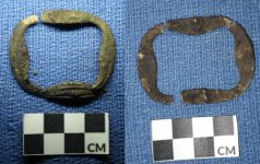
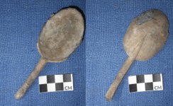
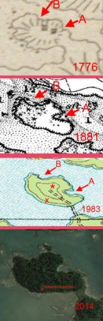
For several months, I have been trying to locate a long-forgotton homestead on a 12 acre, uninhabited island connected by a sandbar to the much larger Maine island where I live. The homestead consisting of two buildings were shown on an 1770's hand-drawn map by the British map-maker Des Barre. On subsequent maps, there is no evidence of the homestead. Combining data from that map, an 1881 USCGS map, a 1983 USGS map and many years of Google Earth imagery, I thought I found the site. Clues were a prominent height of land on the center of the island with the terminal end of an overgrown cart path. Searched the area several times, despite a maze of tangled dense blowdown. Found nothing at this site -- not even 'iron' signals. Near the end of the day's vist to the island, I decided to bushwack the perimeter of the island just inland of the shoreline. Almost 3/4 the way around the island without a 'peep' from the metal detector, suddenly sparse 'iron' signals started to occur. In the midst of those signals, I had two 'high tone' signals about 3' apart. Fortunately, there was only about 3" of frost in the ground and I was able to dig without too much effort. I was rewarded with these two artifacts: a 'rat tail' pewter spoon and fragments of a small brass shoe buckle! Searching the nearby area, I found what looked like a small cellar hole, but no significant signals. A GPS waypoint was recorded for the site. It is on the 'wrong side' of the island and almost at the water's edge -- not consistant with the site locaton on the 1770's map, not at the height of land, and several hundred feet from the end of the old cart road. Perhaps an earlier site?
With 2' of snow forecast for the coming week, I doubt I'll be back there until late March. Glad I recorded a GPS waypoint!
Meanwhile, can anyone suggest an age for these artifacts? I am sure that they are pre-1770, but possibly how much earlier?
Happy hunting,
--Bert