
Gauntlet
Forum Supporter
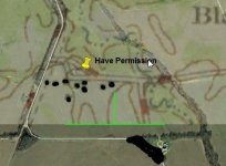
Been playing with Google Earth and a 1950's map that showed house locations on it. It would seem a site I knew where one house stood (for which I already have permission once the farmers done), had several around it, as well as a couple roads which are long gone as well.
The white line roads are current/existing. The black dots I added to darken where it showed the homes on the 50's map overlay. This is now just an open piece of farm ground.
C'mon Fall!!!
The white line roads are current/existing. The black dots I added to darken where it showed the homes on the 50's map overlay. This is now just an open piece of farm ground.
C'mon Fall!!!


 Plus about 40% of the country is "South of Graceland"