Seven
Forum Supporter
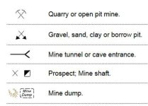
Some have asked me to post some info on finding old sites by using old USGS historical map.
http://youtu.be/w_h2UNsbGRk
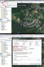
Here is link to my research video on YouTube. Hope this helps.
The link to get free USGS maps is
http://geonames.usgs.gov/pls/topomaps/f?p=262:18:3248051400687832::NO:RP::
http://youtu.be/w_h2UNsbGRk
Here is link to my research video on YouTube. Hope this helps.
The link to get free USGS maps is
http://geonames.usgs.gov/pls/topomaps/f?p=262:18:3248051400687832::NO:RP::
Last edited: