Analog_Kid
Full Member
Hey guys,
I recently discovered historicmapworks.com, and I'm blown away by it. I'm really excited because for the first time in a long time I feel like I have an advantage.
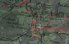
I've been looking at a couple of locations where I grew up. There is an old school house that my uncle went to 50-60 years ago as a boy about 5 miles from my home. I wanted to see if there were any old atlases at mapworks that showed the location of the school house, and sure enough there is.
The problem, however, is that when you overlay the 1867 atlas over Google maps, the 1867 atlas is off by at least half a mile. For instance, the 1867 atlas locates the school about a half mile north of its actual location. Of course, I'd like to fix this problem and make the map as accurate as possible. There are a lot of houses, churches, etc, that I'm finding that are out in the middle of dense forest, such as an estate that once belonged to a doctor. When you lay the atlas over Google maps, the estate is in the middle of dense forest with no roads leading anywhere near it, in spite of the fact that it's inaccurate. I'd LOVE to check this site out.
Since I've been out of the GIS field for some time, are there any mapping packages that allow you to overlay and increase the atlas accuracy by moving the map around and adding more triangulation points? I know that you can move atlases around on Google Earth and stretch them a bit, but from I can tell, it doesn't allow you to add triangulation points.
I recently discovered historicmapworks.com, and I'm blown away by it. I'm really excited because for the first time in a long time I feel like I have an advantage.
I've been looking at a couple of locations where I grew up. There is an old school house that my uncle went to 50-60 years ago as a boy about 5 miles from my home. I wanted to see if there were any old atlases at mapworks that showed the location of the school house, and sure enough there is.
The problem, however, is that when you overlay the 1867 atlas over Google maps, the 1867 atlas is off by at least half a mile. For instance, the 1867 atlas locates the school about a half mile north of its actual location. Of course, I'd like to fix this problem and make the map as accurate as possible. There are a lot of houses, churches, etc, that I'm finding that are out in the middle of dense forest, such as an estate that once belonged to a doctor. When you lay the atlas over Google maps, the estate is in the middle of dense forest with no roads leading anywhere near it, in spite of the fact that it's inaccurate. I'd LOVE to check this site out.
Since I've been out of the GIS field for some time, are there any mapping packages that allow you to overlay and increase the atlas accuracy by moving the map around and adding more triangulation points? I know that you can move atlases around on Google Earth and stretch them a bit, but from I can tell, it doesn't allow you to add triangulation points.