Civil War Bivouac

Justdigginit

Full Member
Joined
Jun 14, 2014
Messages
107
Location
Burkesville KY
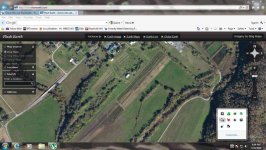
Ok, I'm kind of new at doing CW stuff,, attached is a map of where both north and south bivouacked when they occupied this area (not at the same time of course) but it switched back and forth 3 times according to the locals, (I have paperwork that say 2 times but close enough)
I have exclusive rights and have been told it has never been done (I know ,
never is a long time. But these are BIG fields with a river on 3 sides (very defendable )( I would have picked same place)

So how about one of you CW buffs out there kind of point out where I should start ( it will take me months to due myself).. Along the rivers would be lookouts (outpost) and land has slight slop to the south (lower part of picture). If you look real hard you can see the two rivers, they show up brown.. Does one spot stand out more than another?? Officers in the middle?? Both pieces of paper I have on this say upward of 1200 men at a time. *this is not the cannon placement I have talked about in earlier notes.
I also know that in the lower part of the field (where the two rivers meet) was an Indian camp long before the war-- not that it has anything to do with the CW..

SO Help !! :?: I'll take my time and do it right ~!

Edit: oops maybe I should have put this in war relic hunting !!??
 

Attachments

  • Hunt field.jpg
    Hunt field.jpg
    72.7 KB · Views: 155
Men and horses need water. I would start at the rivers edge and hunt in. Also if it was winter quarters they would have built shelters. Look for sunkin holes and even field stone in a square shape. Once you find something I would grid off that area and hit it hard. Hope this helps and good luck.
 
If it's farmland id look on the outskirts of the fields.

In the water..high points..

Maybe find older maps, civil war maps? or topographical maps to reference as well.

Check historicaerials.com for older images and topographical maps...won't go back that far but maybe see some land changes to help.

Search the maps on library of congress website.

Items could be spread out all over if the land has ever been farmed.
 
Men and horses need water. I would start at the rivers edge and hunt in. Also if it was winter quarters they would have built shelters. Look for sunkin holes and even field stone in a square shape. Once you find something I would grid off that area and hit it hard. Hope this helps and good luck.

You can't see it well in the picture but just to the NW of a white roofed barn in the middle there is a circular indentation in the ground that is half full of water.. It looks out of place as a natural occurrence and would look to be man made ( I would suspect a watering hole !??) The rest is wide open,, will look for indentation in the ground.. Its been a big hay field but I'm sure its been planted with other crops as well.. I can't tell about the barn,, its a pole barn, looks to be very old (except for new roof),, officers quarters ?? or operations?? Will also look for campfires (burnt areas)..

Thanks for all advice !!! Will let you know what I find if anything..
 
If it's farmland id look on the outskirts of the fields.

In the water..high points..

Maybe find older maps, civil war maps? or topographical maps to reference as well.

Check historicaerials.com for older images and topographical maps...won't go back that far but maybe see some land changes to help.

Search the maps on library of congress website.

Items could be spread out all over if the land has ever been farmed.

Will check on those today,, so around the edges of the field (at tree line) and high land points in the water.. This is going to be hard to map (grid) out as its about 40 ar. I don't think this is going to be a One time expedition. I could see this taking months or years.. Thought I would first do a quick scan over most of the land , then cut down into squares that look most interesting, do them,, and go back and do the rest later.. Field is short now but when it starts to grow up, I'll have to quit till they mow it again,, "Snakes".. but should be able to do around the edges then..
Tnx for the help!!
 
Well high lands tend to make good vantage points to be positioned but better would be probably the edges of the fields and water just because things could get washed there over the years of storms and who knows what or dropped and people sometimes forget to look there.

Either way you probably have a lot of fun work ahead of you and should check it all as well as possible. Stuff could be basically anywhere at this point.

Make sure to post your finds ! GL and HH!!
 
Back
Top Bottom