dsmith14469
New Member
Just got my metal detector over the weekend and started researching location, lots of great info on here about finding old maps but how to read them?
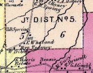
On the attached map it shows the property lines and old owners. Do the squares on the maps indicate house locations? Newer maps don't show them possible because the land was bought by a town to convert into a reservoir. Is my thinking correct or do the squares mean nothing?
Thanks
On the attached map it shows the property lines and old owners. Do the squares on the maps indicate house locations? Newer maps don't show them possible because the land was bought by a town to convert into a reservoir. Is my thinking correct or do the squares mean nothing?
Thanks